 |
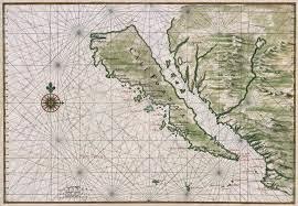
| California as an island |
There are some great stories like how California drifted off into the ocean from 1622 to 1747 (it was still depicted as an island on a map made in Japan as late as 1865) or the 'legendary' and extensive Mountains of Kong in West Africa which never existed, even though they appeared on maps from 1798 to 1892.
I have always loved maps. (See this post from five years ago). Whether it's staring at the one of Mexico on our study wall, leafing through an atlas, or watching me as a blue dot progress along Paseo de la Reforma. Where would we be without them? Lost, I guess.

No comments:
Post a Comment